Solar Activitiy
Solar Flare Data Sources
Huge Triangular Object
Inside Sun
Huge Unidentified Object
Next To Sun
Important Solar Disturbance
Updates
The Sun Is In A Period Of
High X-Class Flare Activity
Earthquake
and Volcanic Activitiy
Reports of High Activity
Disturbing Coincidence in
Mexico prior to 7.9 quake
Obama Executive Order
Terral Croft Prediction
Earthquake Watch During
Passage of Comet Elenin
(Aug-Dec2011)
Ring of Fire April 2009
Earth Archaeology,
Ancient History &
Human Evolution
Earth
and Ancient
Astronauts
Earth Archaeology,
Ancient History and Human Evolution
"Lemuria and
Atlantis: Studying The Past To Survive
The Future," by Shirley Andrews
"Towards a New Alchemy: The Millennium Science," by
Nick Begich
"Extraterrestrial Visitations
from Prehistoric Times to the Present," by Jacques
Bergier (1970)
"Mysteries From Forgotten
Worlds," by Charles Berlitz
"The Mystery of Atlantis," by
Charles Berlitz
"The Gods of Eden," by William
Bramley (1989)
"The Greatest Story Never Told," by Lana Cantrell
"One Hundred Thousand Years of
Man's Unknown History," by Robert Charroux (1963)
"Technology of the Gods: The Incredible Sciences of
the Ancients," by David Hatcher Childress
"Paradox: The Case For The
Extraterrestrial Origin of Man," by John Philip
Cohane (1977)
"Did Spacemen Colonise the
Earth?" by Robin Collyns (1974)
"Lost Tomb of Viracocha," by
Maurice Cotterell
"God Drives A Flying Saucer," by R.L.
Dione (1969)
"The Book of the Damned," by
Charles Fort (1919)
"Psychic Archaeology: Time
Machine To The Past," by Jeffrey Goodman
"Lines to the Mountain Gods:
Nazca and the Mysteries of Peru," by Evan Hadingham
"Humanity's Extraterrestrial
Origins," by Arthur David Horn with Lynette Anne
Mallory-Horn
"In Search of Ancient Mysteries,"
by Alan and Sally Landsburg
"The Outer Space Connection," by
Alan and Sally Landsburg
"Colony: Earth," by Richard
Mooney (1974)
"Coming of the Gods," by Jean
Sendy
"Those Gods Who Made Heaven and
Earth," by Jean Sendy (1969)
"Divine Encounters,"
by Zecharia Sitchin
"Genesis Revisted," by Zecharia
Sitchin
"The 12th Planet,"
by Zecharia Sitchin (1976)
"The Lost Realms,"
by Zecharia Sitchin
"The Stairway To
Heaven,"
by Zecharia Sitchin
"The Wars Of Gods
And Men," by Zecharia Sitchin
"When Time Began," by Zecharia
Sitchin
"Super Scientists of Ancient Atlantis & Other
Unknown Worlds," by Brad and Sherry Steiger
"Hitler's Treasure of the Ancient
World," by Wendelle C. Stevens
"The Sirius Mystery," by Robert K.G. Temple
(1976)
"Alien Identies," by Richard Thompson
(1993)
"We Are Not The First," by Andrew Tomas
(1971)
"The Home of the Gods," by Andrew Tomas
(1972)
"Temple of the Stars," by Brinsley LePoer
Trench (1962)
"Mystery of the Ancients: Early Spacemen
and the Mayas," by Craig and Eric Umland (1974)
"Chariots of the Gods?" by Erich Von
Daniken (1968)
"Gods From Outer
Space," by Erich Von Daniken
"Gold of the Gods,"
by Erich Von Daniken
"In Search of Ancient Gods,"
by Erich Von Daniken
"Miracles of the Gods,"
by Erich Von Daniken
"Pathways to the
Gods,"
by Erich Von Daniken
"The Return of
the Gods," by Erick Von Daniken
"Von Daniken's Proof,"
by Erich Von Daniken
"Pole Shift," by John White
"Our Mysterious Spaceship Moon,"
by Don Wilson (1975)
"The Monuments of Mars,"
by Richard Hoagland (1987)
This
page designed by Rick Keefe (c)2006-2014 Rick Keefe. All rights reserved. Specific copyrighted content,
images and links
are the property of their original owners.
1)Strength
and Duration. Maritza and I were sitting on the
couch watching anime (Zetman), and she
said that she thought she felt a quake. I had my had on
her thigh, and I could
feel the water and flesh of her thigh vibrating. I said
that I felt it, too. The animals were looking up very
puzzled by the quake. The quake lasted over thirty
seconds.
2) North-South Alignment with
other quakes. There had just been seven hours
before an
Earthquake in Sonora [M4.4 - 16km SE of Alamos, Mexico
2014-06-28 21:09:43 UTC,
depth=18.3km (11.4mi)]and
one
just minutes before in Utah [M3.2 - 13km S of Mount
Pleasant, Utah 2014-06-29
04:52:46 UTC, depth=5.3km (3.3mi)], and if you drew a
straight line between
them, that was very close to where the epicenter of this
quake hit in Duncan, Arizona.
3) Nuclear Danger. We have a nuclear reactor
called the Palo
Verde nuclear plant that is only about 250 miles
from the epicenter in Duncan, Arizona.
There is also a Nuclear Waste plant in Carlsbad, New
Mexico, some 300 miles to the east of the epicenter,
which has been having serious
problems with radiation leaks.
4) Depth. The depth of the quake was very
shallow, and these are the most dangerous: it was only two
miles below the surface of the Earth. The only other time
that I felt an earthquake in Tucson was four years ago on
Sunday, April
4, 2010, when in the afternoon there was a 7.2
earthquake in Baja Mexico, which was felt strongly
in Tucson, and even caused water to be tossed outside of
swimming pools here in town and also in California.
Here also the depth
of the quake was only 6.2 miles, which means it was
poorly constrained and very dangerous. Here's an ABC news
story on that Baja
Quake.
The quake has been followed by three
aftershocks within 12 hours...
+(8
minutes later) 3.5 41km WNW of
Lordsburg, New Mexico 2014-06-28 22:08:44 UTC-07:00 5.0
km
+(3
1/2 hours later) 3.4 49km NW of
Lordsburg, New Mexico 2014-06-29 01:25:19 UTC-07:00 5.0
km
+ (9
1/2 hours later) 3.6 46km WNW
of Lordsburg, New Mexico 2014-06-29 07:33:59 UTC-07:00
5.0
km
(9
1/2 hours later)
Earthquake
data
from USGS prior to and after the quake... http://earthquake.usgs.gov/earthquakes/map/
·6.8 170km SSE of
Mata-Utu, Wallis and Futuna 2014-06-29
08:52:23 UTC-07:00 10.0 km
·2.5 21km S of Valdez, Alaska 2014-06-29 07:57:07
UTC-07:00 100.0 km
·3.0 48km ESE of Glennallen, Alaska 2014-06-29
07:52:05 UTC-07:00 100.0
km
·3.6 46km WNW of Lordsburg, New Mexico 2014-06-29
07:33:59 UTC-07:00 5.0
km
·5.7 157km NNW of Visokoi Island, 2014-06-29
07:32:49 UTC-07:00 10.0 km
·5.6 151km NNW of Visokoi Island, 2014-06-29
07:20:37 UTC-07:00 10.0 km
·5.0 176km NNW of Visokoi Island, 2014-06-29
06:41:23 UTC-07:00 10.0 km
·3.2 11km E of Healy, Alaska 2014-06-29 05:25:45
UTC-07:00 100.0 km
·5.1 169km NNW of Visokoi Island, 2014-06-29
05:11:20 UTC-07:00 10.0 km
·4.9 172km NNW of Visokoi Island, 2014-06-29
05:05:38 UTC-07:00 10.0 km
·2.7 135km NNW of Charlotte Amalie, U.S. Virgin
Islands 2014-06-29
05:01:10 UTC-07:00 28.0 km
·4.3 63km ESE of Karpathos, Greece 2014-06-29
04:19:07 UTC-07:00 10.0 km
·3.0 14km N of Road Town, British Virgin Islands
2014-06-29 03:18:48
UTC-07:00 35.0 km
·3.1 50km NNE of Larsen Bay, Alaska 2014-06-29
03:16:12 UTC-07:00 39.7 km
·4.8 21km S of Little Sitkin Island, Alaska
2014-06-29 01:54:45 UTC-07:00
90.4 km
·5.1 164km NNW of Visokoi Island, 2014-06-29
01:28:55 UTC-07:00 10.0 km
·3.4 49km NW of Lordsburg, New Mexico 2014-06-29
01:25:19 UTC-07:00 5.0
km
·5.1 152km NNW of Visokoi Island, 2014-06-29
01:21:04 UTC-07:00 10.0 km
·6.9 154km NNW of Visokoi Island, 2014-06-29
00:52:56 UTC-07:00 16.5 km
·2.6 8km SW of Aguanga, California 2014-06-29
00:39:46 UTC-07:00 15.2 km
·2.5 23km ENE of Cantwell, Alaska 2014-06-29
00:23:48 UTC-07:00 0.2 km
·5.0 120km E of Bitung, Indonesia 2014-06-29
00:19:24 UTC-07:00 34.4 km
·4.4 29km NE of Cantwell, Alaska 2014-06-28
23:58:44 UTC-07:00 9.4 km
·6.2 134km ESE of Iwo Jima, Japan 2014-06-28
22:56:31 UTC-07:00 43.2 km
·3.0 46km ESE of Middleton Island, Alaska
2014-06-28 22:17:28 UTC-07:00 26.1
km
·3.5 41km WNW of Lordsburg, New Mexico 2014-06-28
22:08:44 UTC-07:00 5.0
km
·5.2 50km NW
of Lordsburg,
New Mexico 2014-06-28 21:59:33 UTC-07:00 5.0 km
and just prior...
·3.2 13km S of Mount Pleasant, Utah 2014-06-28
21:52:46 UTC-07:00 5.3 km
·3.0 11km SSE of Mount Pleasant, Utah 2014-06-28
19:08:26 UTC-07:00 5.0
km
·3.2 24km WSW of Bolinas, California 2014-06-28
18:51:34 UTC-07:00 5.6 km
·4.2 11km S of Mount Pleasant, Utah 2014-06-28
17:56:22 UTC-07:00 5.1 km
·2.5 69km ENE of Cape Yakataga, Alaska 2014-06-28
17:04:45 UTC-07:00 12.4
km
·4.6 115km E of Shikotan, Russia 2014-06-28
16:59:32 UTC-07:00 35.7 km
·4.4 16km SE of Alamos, Mexico 2014-06-28 14:09:43
UTC-07:00 18.3 km
·2.8 116km SSW of Kaktovik, Alaska 2014-06-28
13:24:56 UTC-07:00 4.5 km
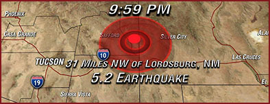
(Reuters) - A
5.2-magnitude earthquake near
the border of Arizona and New Mexico rattled a
significant swath of the U.S.
Southwest late Saturday but caused no major damage or
injuries, the United
States Geological Survey said.
The
earthquake was centered about 31
miles (50 km) northwest of the city of Lordsburg, New
Mexico, and could be felt
some 150 miles (240 km) west in the city of Tucson,
Arizona, and 300 miles east
(480 km) in Roswell, New Mexico, the USGS and local
media reported.
The
quake hit at 9.59 p.m. local
time at a depth of about 3 miles (5 km) and was followed
by two small
aftershocks, the USGS said.
It
knocked pictures from walls and
caused light fixtures to swing, local media reported. It
also prompted scores
of people across the region to call 911.
In
the southeastern Arizona town of
Thatcher, residents saw roads and structures swaying.
"It
just kept shaking and
shaking, and I grabbed the arm of the girl next to me,"
Jennifer Taylor, a
dispatcher for the Graham County Sheriff's Office, told
KPHO-TV. "We went
out to the patio and looked up and our radio tower was
shaking."
In
El Paso, Texas, about 150 miles
(240 km) east of the epicenter along Interstate 10,
local officials tweeted
that staff inside the El Paso International Airport
control tower said they
felt the quake.
(Reporting
by Victoria Cavaliere;
Editing by Colleen Jenkins and Frances
Kerry)
Also I checked out this
page about the low probability of an
earthquake threat there:
http://www.homefacts.com/earthquakes/New-Mexico/Hidalgo-County/Lordsburg.html,
which
said that in the next 50 years, Lordsburg had only an
11.29% chance of
having a 5.2 quake.
Lordsburg, NM Earthquake Probability
Very Low Risk Area
The USGS
database shows that there
is a 15.86% chance of a major earthquake within 50km of
Lordsburg, NM within
the next 50 years. The largest earthquake within 30 miles
of Lordsburg, NM was
a 3.2 Magnitude in 1981.
Probability of earthquakes within the next 50 years
MagnitudeProbability
5.015.86%
5.113.39%
5.211.29% (so this was only a 1:10 chance over
the next 50 years!)
The U.S. Geological Service reported a 5.2 magnitude
earthquake that was
felt across Southern Arizona.
It originated about 30 miles northwest of Lordsburg, N.
M. Officials say
that it was felt strongest in Greenlee and Cochise
counties in Arizona.
The USGS will be receiving reports from sensors around
the world during the
next several hours and could revise the magnitude as more
accurate numbers come
in.
The communities of Safford and Willcox likely felt some
of the strongest
shaking - The small community of Duncan, AZ is the town
closest to the center.
Here is the official statement from the National Weather
Service:
"Earthquake Report - National Weather Service, Tucson, AZ
- 10:20 PM
MST - Saturday June 28th 2014
An Earthquake was felt weakly to moderately by many
people across
Southeastern Arizona Including
Tucson...Douglas...Willcox...and Sierra Vista.
No Damage or injuries have been reported. The earthquake
was initially rated at
magnitude 5.2 by the US Geological Survey and Occurred at
10 PM MST. The location
was noted as 50 KM Northwest of Lordsburg, NM...Which is
near Duncan in
Southern Greenlee County, AZ. Lat 32.607 Lon 109.151
Information released in this statement is preliminary.
Updates...Including
Richter scale magnitude...will be provided as more
information becomes
available from the National Earthquake Information Center
in Golden
Colorado."
Tucson News Now has been flooded with calls from people
all over Tucson and
neighboring cities and towns with reports of feeling
tremors. Reports have been
coming in from Greenlee, Graham, Cochise, Santa Cruz,
Gila, and Pima county
tonight.
An aftershock has already been generated, but it was
significantly smaller
than the first earthquake - The aftershock measured 3.5 at
10:08 PM.
And
this article on
how rare earthquakes in Arizona are:
Posted:
Jun 29, 2014 1:11 AM Updated:
Jun 29, 2014 1:14 AM
By
Aaron Pickering
The earthquake that hit Southern Arizona on Saturday
night at 9:59 PM is
rare, no…its extremely rare.
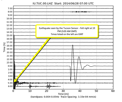
The Tucson seismograph captured this image of the quake:
The 5.2 magnitude earthquake centered in Southern
Greenlee County gave people
a jolt from Safford to Douglas, Sierra Vista to Tucson. It
only lasted for a few
seconds, but it was strong enough that many people stopped
what they were doing
to pay attention. Although no injuries or damage was
reported, we wanted to
take a look at how rare these events really are.
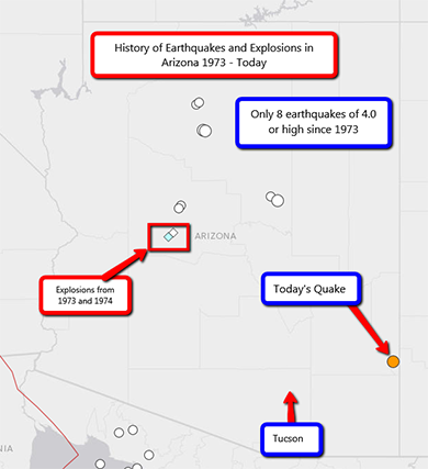
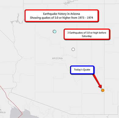
Unlike California, Arizona experiences very little
seismic activity. Not
including the most recent quake, the USGS records show
only eight earthquakes
measuring 4.0 or larger since 1973. Interestingly enough,
if you look at
earthquakes measuring 5.0 or higher, that number drops to
just three quakes,
with the largest measuring at 5.3 near Flagstaff in 1993.
A study published by the USGS in 1970 shows only 12
moderate earthquakes
inside the borders since Arizona became a state in 1912.
According to the USGS, "no earthquake in recorded history
has caused
deaths or injuries in Arizona."
And here's another
article on the
history of earthquakes in Arizona:
The earliest documents which describe Arizona earthquakes
were those
recorded at Fort Yuma, located in the 1800's on the
California side of the
Colorado River. Shocks which probably centered in the
Imperial Valley of
California, or in Mexico, have been noted there since late
1852.
No earthquake in recorded history has caused deaths or
injuries in Arizona.
In the past century or more, 14 tremors of intensity V to
VII have centered
within its borders, of which 12 were reported after
Arizona entered the Union
in February 1912. All of these shocks, however, were
moderate in intensity,
with one intensity VII, one VI-VII, four VI, and eight V.
Probably the most famous earthquake in this region
occurred in 1887 near
Bavispe, Mexico, about 190 miles southeast of Tucson. The
temblor caused great
destruction near its epicenter. From Guaymas to Nogales,
Mexico, Benson and
Tucson, Arizona, and at towns as far distant as
Albuquerque, New Mexico, water
in tanks spilled over, buildings cracked, chimneys were
toppled, and railroad
cars were set in motion. An observer at Tombstone, near
the Mexican border,
reported sounds ``like prolonged artillery fire.''
The first damaging earthquake known to have centered within
Arizona's
borders occurred on January 25, 1906, the year of the
great San Francisco
earthquake, and of a damaging series of shocks at Socorro,
New Mexico. The
shock was violent at Flagstaff, about 115 miles north of
Phoenix.
The cumulative terror produced by a series of 52
earthquakes, from September
10 to 23, 1910, caused a construction crew in the Coconino
Forest near
Flagstaff to break camp and leave the area. Boulders
rolled down on their camp
from nearby mountains, and the earth maintained a constant
quiver. The shocks
grew in intensity until September 23, when a very strong
shock raged throughout
northern Arizona. It was so severe north of the San
Francisco Mountains that
Indians fled from the region.
A tremor on August 18, 1912, caused a 50-mile-long crack
in the earth north
of the San Francisco Range. Houses were damaged at
Williams, and the shock was
strong in Coconino County, north of Flagstaff. Rockslides
roared down the
mountainsides, and the earth seemed to roll ``like waves
on the Colorado
River.''
A shock that cracked walls and plaster at Wellton,
located a few miles east
of Yuma in southwestern Arizona, occurred January 2, 1935.
Although few residents
of the small town were frightened by the tremor, everyone
felt the ground
quiver, and homes shake.
Eight days later, a slightly stronger earthquake awakened
sleepers at Grand
Canyon, 175 miles north of Phoenix. Many were frightened
by the distinct
subterranean rumble and the movement of their houses.
Walls were cracked in
some cases, and rockslides occurred in the mountains.
Three slight foreshocks
were felt by Grand Canyon residents during the first week
of January, and one
very minor aftershock was noted on January 15.
On January 16, 1950, a strong earthquake in Apache County
left several
cracks in the ground as it rumbled through the small town
of Ganado. The
cracks, one-half inch wide and up to 12 feet long,
extended in a north-south
direction near the Ganado trading post.
Abridged from Earthquake
Information
Bulletin, Volume 2, Number 3, May-June 1970
For a list of earthquakes that have occurred since this
article was written,
use the Earthquake
Search.
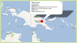
A major earthquake has hit New Guinea
again, following yesterday's 5.7, and the 6.4 from March
14th. Also, earthquake reporter Dutch
Sinse is reporting that Google has suspended his
account as of today, and Terral
Croft is reporting that six members of his reporting
team are "under attack." The timing of all of this, just
after Croft's press release from Sunday the 18th
predicting these events, seems very suspicious. Both
earthquake reporters have tied the U.S. government HAARP
Project to earthquakes.
Especially disturbing is the emergency
drill that was staged in the state of Chiapas,
Mexico for an earthquake of magnitude 7.9, when the 7.8
earthquake struck in the nearby state of Guerrero only two
minutes difference from the simulation drill. Add to this
strange confluence of events that Obama's daughter was
visiting in the area of the earthquake.
March 20, 2012 7.4 to 7.9 Earthquake
rattles Southern Mexico
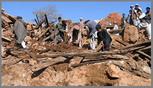
A major earthquake has hit southern
Mexico, centered in Oaxaca, and reaching Acapulco and
Mexico City. See this L.A.
Times page for videos and photos from the incident,
as well as this article from London's Daily
Mail. By the last account, over eight hundred homes
were damaged by this quake.
March 19, 2012
Obama Makes Executive
Order on March 16, 2012:
National Defense Resources Preparedness As unbelievable as it
sounds, Pres. Barack Obama has signed an executive order
that may be paving the way for peactime martial law in the
United States. On March 16th, he signed the "National
Defense Resourches Preparedness" order as law.
You can view the list of Obama
executive orders and keep an eye on future press
releases from the White
House.gov website.
March 19, 2012
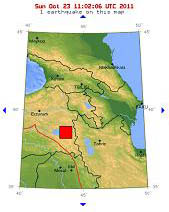
Earthquake prediction
related to CW Leonis
A small group of non-professional earthquake
analysts out of St. Petersbug, Florida have offered a press
release on March 18th, and are expecting a major
earthquake to occur by Thursday, March 22, 2012.
Here is the statement by Terral
Croft:
MARCH 22, 2012 EARTH AXIS WILL SHIFT FIVE INCHES WITH a
NINE MAGNITUDE QUAKE EXPECTED in a PACIFIC OCEAN EVENT,
WHEN EARTH PASSES THROUGH A GRAVITY TROUGH CONNECTING THE
SUN AND an INBOUND HEAVY-MASS OBJECT
St. Petersburg, Florida – Our researchers have discovered
a pattern of seismicity going back to 1965 that has
transitioned into large magnitude events including Earth
axis shifts on a regular 188-day cycle. The most-recent
events include the February 27, 2010 8.8 event in Chile,
the September 4, 2010 7.1 event at Christchurch, New
Zealand, the September 15, 2011 7.3 event in Fiji and the
March 11, 2011 9.0 Japan event. The next timeline event is
expected to take place according to our calculations on
March 22, 2012 at 4:58:34 UTC, when Earth will pass
through the gravity trough connecting the Sun and a
heavy-mass object (HMO) being tracked out of the Leo
Constellation. The Earth axis is expected to shift five to
six inches like the four-inch shift with Japan event and
the three-inch shift with the Chile event.
Saturn is currently in the Virgo Constellation next door
to the Leo Constellation where the ringed planet also
passed between the Sun and this HMO to develop an extra
ring and the super storm now raging in the northern
hemisphere. The evidence indicates that Jupiter’s
liquefying core, Venus’ slowing rotation with Mars’ and
Uranus’ increased seismicity are all perturbations
associated with our inbound HMO. The last time Saturn
experienced this storm type was thirty years ago, when the
planet passed between the Sun and Leo Constellation. Our
team is also tracking the U.S. Government response to
these threats, which includes Presidential, NASA, DHS and
FEMA Preparations.
Our research team anticipates that HAARP multi-frequency
wave signatures will begin transmitting on March 19, 2012
at 4:58:34 UTC precisely seventy two hours prior to the
expected event. The team also expects to see increased
four to six magnitude quake swarm activity at the ‘event’
location. Everyone living in or around a seismic area
should be warned to brace for one of the top five seismic
events in recorded history on March 22, 2012 right around
the equinox."
[End of press release]
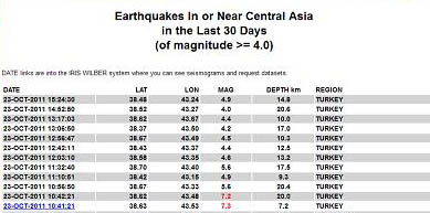
October 24, 2011 9:30am
Tucson time
What I have found odd is that the earthquakes have
been quiet
for most of the last 24 hours on the Asian side of the
Ring of Fire,
and along the western South American coast,
but instead concentrated and repeated tremors are
occurring
along the Mediterranean faults in Turkey and Greece
Updated
November 15, 2011
Commentary: October 16, 2011 by Rick
KeefeNEW
Since following earthquake data, I have
noticed a trend by the USGS (United States
Geological Survey) that indicates a pattern of their
office downgrading earthquake magnitudes, after the "event
has been reviewed by a seismologist."
Here are four recent examples:
*The Russia quake of October 14 2011
was downgraded from a published 6.6 to 6.1
*The Oregon quake of October 12, 2011
was downgraded from 5.9 to 5.3.
*The Vancouver quake of September 9,
2011 was downgraded from a 6.7 to a 6.4.
*The Alaska quake of September 2, 2011
was downgraded from a 7.1 to a 6.8.
There have been numerous others that I have seen
downgraded from 0.1 to 0.3 magnitudes,
and I have not seen a single event that was upgraded in
magnitude. I have found this
reporting very unscientific, unsettling, highly
irresponsible, and even criminal.
Today, I discovered this article: Why
the Lake Mead earthquakes Should Give You
Nightmares and am appalled to find that the USGS is
deleting earthquakes from its
database, and under-reporting at best. This is a large
signal that those higher in authority
are purposely mis-informing the public about the growing
scale of seismic disturbances. Update
November 15, 2011: Here is another
example
of earthquake
data manipulation through USGS data
sources, caught live by an observer on November 5,
2011 as the Oklahoma Earthquakes were occurring.
Commentary:
October 6, 2011 by Rick Keefe
Already
since
October
5th,
there
has
been
a
climb
in
the
magnitude
of
earthquakes
back
into the 5+ and 6+ range, and numerous volcanoes
including the Canary Islands El Hierro,
Iceland's Katla Volcano, Indonesisa's Anak
Krakatau Volcano, Costa Rica's Rincon de
la Vieja Volcano, and Italy's Mount Etna
Volcano are showing intense increased
seismic activity and reactivation from
dormancy.
If Comet Elenin, or any
larger object associated with its path,
is actually affecting the geo-magnetics on
Earth and between the Earth and
the Sun and thus affecting solar flares,
eathquakes and volcanoes, then using the JPL
and NASA Elenin Tracking Model,
it appears that the period between October
15th and 19th,
2011 has the potential to be more
dangerous in terms of large-scale events.
And if HAARP
is a contributing factor or amplifier in
any way, then we must put forth as much
positive and gentle energy as possible, so
that all dangerous effects are diminshed
to whatever degree that our positive and
healing energy can effect such events.
April 26, 2009
Ring of Fire Unusually Active this April, 2009
The
incidents and frequency of large tremors and earthquakes
in the middle of April may be cause for greater concern,
but if it is, our government and the media haven't let
on so far.
Although not limited to the
cases to be listed below, what follows are a list of
reports gathered last week as I trolled through the
world news articles, and began to suspect a trend and
then started a deeper search which led to these
discoveries tucked away on the deep, back pages of the
internet news engines:
--March 26th 12:35am (5.8 earthquake) Northern Peru (along the
western border of the Nazca Plate) resulting in
Mudslides April 16th in Chamanachucho and Aricapampa burying 25 homes
--throughout April, Mt.
Redoubt Volcano in Alaska active, since March 22 (western
border of the North American Plate)
-- April 7th 9:13am (4.7earthquake)
Guatemala (on a
western border of the Cocos Plate)
--April 7th 12:12pm (4.6 earthquake)
Anchorage, Alaska (western
border of the North American Plate)
--April 11th 4:22am (4.8 earthquake)
Michoacan state,
Mexico (on the
northern
boundary of the Cococs Plate)
--April 14th 4:37am ( major earthquake, 3.9 aftershock)
Yunnan Province, China
(on the western edge of the Euroasian Plate) 16,000 people injured
--April 15th 4:23pm (5.0 earthquake) Amani-oshima Island, Japan
(on the northwestern border of the Pacific Plate)
-- April 15th 3:01am (6.5 earthquake)
North Sulaesi, West
Papua and West Sumatra, Indonesia ( Indonesia
pop. 230 million people plus animals) (along the top
boundary of the Australian Plate)
-- April 15th 2:00 am (4.4 earthquakes) Central Mindanao,
Philippines (along the southern border of the
Phillippine Plate)
-- April 15th 8:45am (3.9 or less earthquake)
Sri Lanka (just
beyond the northwest
corner of the Australian Plate)
--April 16th, La Cumbre Volcano lava flow, Fernandina of
the Galapagos Islands
off Ecuador (on the western border of the
Nazca Plate) killing
rare wildlife
--April 16th 10:08pm (6.3 earthquake) Pacific
Ocean 80km northwest of Iquique, Chile (on the
western border of the Nazca Plate)
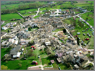
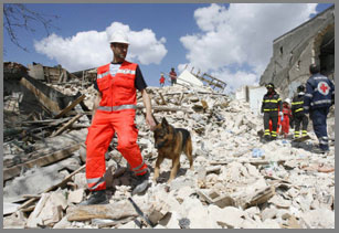
Considering the Central Italy 6.3
earthquake on April 6th that has left
394 people dead and 50,000 injured or homeless
and the Nangarhar Province, Afghanistan 5.5
& 5.1 earthquakes on April 16th that
Afghanistan
left over 40
people dead and hundreds of homes destroyed, it
is obvious that the Earth is in the midst of a period of
high seismological upheaval.
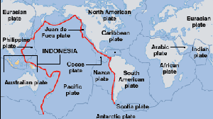
On all sides of the "Ring of
Fire," citizens and scientists should be both concerned
and ramping up preparations for the contingency of
having to deal with a devastating earthquake.
Here in the United States,
Hawaii, Alaska, Washington, Oregon, and California need
to take these series of seismological incidents very
seriously, and our federal government needs to be
prepared to help the states now for major earthquake
preparedness. Risk management experts suggest that a 7.0
earthquake in the San Francisco area "could kill 4,500,
injure 50,000, leave hundreds of thousands homeless."
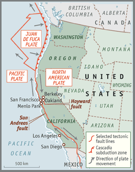
The Cascadia region of Oregon,
Washington and British Columbia is along the edge of the
Juan de Fuca Plate,
Juan De Fuca Plate
which pushes under North America. The last large
earthquake in that region was in 1700 of a 9.0
magnitude, equivalent to 30,000 6.0 earthquakes.
Coastline cities around the
Ring of Fire need to immediately step up preparedness
efforts and public information efforts in order to
minimize loss of life to humans and animals.
Non-scientific warnings are
also being directed to UFOHypotheses, and include:
1) E-mail
circulating Singapore warning of impending
earthquake around July 22nd, the same day as a solar
eclipse.
2) Native-American warnings to stay away from the
coastlines, especially those areas with nuclear reactors
which will poison the water should they be damaged or
submerged due to earthquake or tsunami. This is of
special concern for Japanese residents in the
Kashiwazaki-Kariwa area where the world's
largest nuclear power plant has just been re-activated
after being shut down two years ago following a 6.8
earthquake on July 16, 2007.
3) News articles by KING
News in Seattle and The
Economist
which suggest earthquake preparedness is crucial.
4) Psychic who warns of a seismic disaster to occur in
San Francisco this summer with a track record of high
accuracy for thirty years of predictions.
5) Contactee information warning of a high probability
of danger from the Juan De Fuca Plate, that would
devastate Oregon and Washington states.
6) Yellowstone
tremors are ganging together and more frequent.
While there are no good
solutions to such enormous dangers as these
potentialities, if some of the people who live in the
U.S. coastlines were to migrate and move toward the
central states, two good effects could occur:
a) A potential smaller number of dead, injured and
homeless due to an earthquake and/or tsunami.
b) Integration of coastline populations which are
generally multi-racial and multi-cultural with the
homogenous central United States population, which could
bring a greater degree of integration to rural American
areas, leading to improved social balance.
My feeling is that we might as
well look for the positive benefits of foresight,
preparedness, and sensible action while we can act
before such catastrophes.